- He argues that the country must change its way of thinking and redesign its cities especially drainage systems, roads, and urban planning to withstand the growing volume of floods.
Former Kenya National Union of Teachers (KNUT) Secretary General Wilson Sossion insists that the solution to Kenya’s flooding crisis lies in infrastructure and the misuse of riparian land.
He argues that the country must change its way of thinking and redesign its cities especially drainage systems, roads, and urban planning to withstand the growing volume of floods.
Sossion stresses that current infrastructure cannot save lives and calls for stronger enforcement of environmental laws, particularly against settlements on riparian land.
“Cities must reconfigure infrastructure so drainage systems can handle the rising volume of floods. Current systems cannot save lives, and this challenge extends to the global community,” he said during an interview on Citizen TV’s DayBreak show on March 16, 2026.
He points to the tragic loss of lives in Nairobi, Maai Mahiu, and Elgeyo Marakwet as proof that Kenya must reorganize itself, accept the “new normal,” and adopt stricter, more efficient measures to curb flooding.
Read More
“This includes how we design roads and build new infrastructure. When county and national governments cooperate, we should see projects fast‑tracked to meet the urgency of the moment,” he added.
For Sossion, floods are a clear phenomenon of climate change. He notes that scientists have already given guidelines, yet Kenya continues to suffer extreme droughts and livestock losses alongside devastating floods.
He warns that riparian ecosystems converted into human settlements will inevitably be reclaimed by rivers and floods. While laws exist, enforcement remains weak. He urges the government to impose more stringent regulations and find efficient ways to curb the menace.
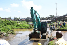
His arguments come as heavy rains on Saturday night, March 14, 2026, triggered a second wave of severe flash flooding across Nairobi, causing both the Nairobi and Ngong Rivers to overflow. This followed a deadly flood event exactly one week earlier.
Heavy rains in cities damage housing by overwhelming drainage systems, flooding homes, weakening building foundations, and displacing residents especially in informal settlements along riverbanks. Poorly planned urban growth magnifies the risks, turning rainfall into a recurring housing crisis.
UN‑Habitat views housing not merely as physical structures but as a fundamental human right and a driver of sustainable urban development. Its “Housing at the Centre” approach integrates housing into national and local urban agendas, emphasizing resilience.
A mapping exercise under the Nairobi Rivers Regeneration Programme has identified 37 neighbourhoods vulnerable to flooding along major river corridors.
In Nairobi East, areas such as Kiambiu, Dandora, Kariobangi, Kayole, Komarock, Njiru, Ruai, Mwiki, Donholm, Savannah, Tassia, and Fedha lie downstream along the Nairobi River and its tributaries.
Nairobi West locations include Madaraka, Lang’ata, Kawangware, Kangemi, Lavington, Westlands, Parklands, Kitisuru, Spring Valley, Kileleshwa, and Chiromo, situated upstream and midstream.
In Nairobi North, Mathare, Korogocho, and Lucky Summer border the Mathare River, while Nairobi Central includes the CBD, Globe, Gikomba, Eastleigh, and the Industrial Area. Nairobi South highlights Kilimani, Kibera, South C, South B, Mukuru Kwa Reuben, and Kwa Njenga, many lying along the Ngong River corridor.
Stay connected with us on WhatsApp and Facebook for instant updates and breaking news as it happens.